
The Complete Guide to the Manatee Pocket
Almost everything in Port Salerno points toward one body of water.
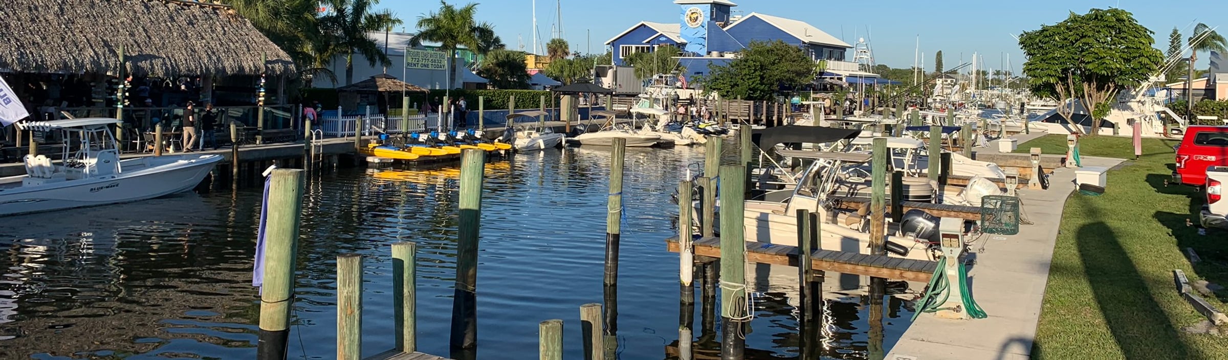
Manatee Pocket shaped the village's commercial fishing industry, its marinas, boatyards, restaurants and waterfront neighborhoods. It is still the center of Port Salerno's identity and the main reason people choose to live, work and boat here.
Understanding the Pocket also explains why one waterfront property suits a particular boat perfectly while another, a few streets away, does not.
What Manatee Pocket Actually Is
Manatee Pocket is a narrow estuarine embayment connected to the St. Lucie River and Indian River Lagoon system near the St. Lucie Inlet. It is a natural water body, not a modern residential canal.
Its shoreline mixes commercial fishing facilities, marinas, boat-repair yards, restaurants, seafood markets, charter operations, waterfront homes, and the smaller creeks and residential canals feeding into it.
That mixture is what makes it distinctive. Commercial boats, large yachts, center consoles, waterfront restaurants and residential docks all sit within a compact area.
A Protected Harbor Near the Inlet
The Pocket is narrow and enclosed compared with the open St. Lucie River or the Atlantic, which generally gives more protection from ordinary wind and wave activity than an exposed shoreline. It also puts boaters close to the St. Lucie Inlet.
Sheltered water plus convenient ocean access is the whole reason commercial fishing, marine repair and recreational boating developed here.
It should not, however, be described as a guaranteed hurricane refuge. Storm surge, extreme wind, flooding, damaged docks and loose vessels reach protected waterways too. Establish a hurricane plan with your marina, insurer or marine professional long before a storm threatens.
The Working Waterfront
Port Salerno still has an active working waterfront. Commercial fishing, seafood unloading, marine repair, charter operations and boat storage are daily life around the Pocket, and Martin County identifies Port Salerno as the location of the county's last remaining commercial fishing dock.
Near the working parts of the harbor, expect early-morning departures, engines and generators, commercial vehicles, loading and unloading, refrigeration equipment, fishing activity, marine repairs and boat-hauling.
This is not a heritage fishing district recreated for visitors. It is a functioning marine environment.
For some buyers that activity is the appeal. Others will prefer a quieter residential creek or a property further from the commercial waterfront. Visit any property you are considering at different times of day, including an ordinary weekday morning.
Marinas and Marine Services
The Pocket carries an unusual density of marine business for a village this size, serving everything from small recreational boats to large yachts needing serious repair or haul-out.
Between them the facilities cover wet slips, transient dockage, dry storage, fuel, repairs, haul-outs, bottom painting, detailing, charter fishing, bait and tackle, and waterfront dining. Rates, availability and vessel limits move, so confirm current information with each marina directly.
Sailfish Marina of Stuart
At 3565 SE St. Lucie Boulevard, near the entrance to the Pocket, and the closest marina to the St. Lucie Inlet. Not to be confused with the separate Sailfish Marina Resort in Palm Beach Shores.
It runs roughly 55 wet slips taking vessels up to about 90 feet, fuel docks with diesel and ethanol-free gasoline, high-and-dry storage, a service yard with a 50-ton travel lift, repair and detailing, and bait, tackle and limited food service.
Its primary route to the inlet does not pass beneath a fixed bridge. That still does not remove the need to verify vessel draft, water depth, current channel conditions, no-wake travel time, slip availability, and beam and storage limits.
Pirate's Cove Resort and Marina
Roughly 50 wet slips accommodating boats and yachts up to about 90 feet, dry-rack storage for smaller powerboats up to around 32 feet, marina utilities, waterfront accommodation, dining and event facilities.
Note that quoted vessel length may include bow pulpits, swim platforms and other projections. Acceptance depends on the boat's complete specifications and current availability.
The Rest of the Roster
- Finest Kind Marina — takes transient guests.
- Mariner Cay — a marina with transient facilities partway down.
- Hinckley Yacht Services — a working yard with a travel lift in the 150-ton class, doing haul-outs and refit work.
Two things worth drawing out. First the range: this harbor serves a 22-foot center console and a 90-foot yacht in the same water. Second the yard capacity — a lift that size means serious refit work happens here, which is why you see boats on the hard that clearly did not come from around the corner.
The County Mooring Field
Martin County runs a managed 36-vessel mooring field on the Pocket, with a harbormaster and a dinghy dock. It is a large part of why this anchorage stays orderly rather than accumulating abandoned hulls the way some Florida harbors do. Capacity and rules are in the Rocky Point guide.
Free August 2026 Treasure Coast Market Report
Get the Treasure Coast Market Report
Martin and St. Lucie county prices, inventory, closed sales, days to contract and negotiating conditions — single-family and condo, in one free PDF.
Eating on the Water
The dining here is concentrated on the Pocket and it is genuinely good, for a reason that has nothing to do with chefs.
The fish comes off boats you can see from the table. A commercial dock still operates here, so the seafood supply chain is measured in yards rather than days and truck miles. That is the entire explanation for why a village of ten thousand eats better fish than most coastal towns three times the size.
What to expect, honestly:
- Casual, waterfront and unpretentious. Plastic chairs and paper towels are common. So is excellent fish.
- Dock and dine works. Several places have dockage, so arriving by boat is normal rather than a novelty.
- Fish houses are separate from restaurants. You can buy fish to cook rather than fish to be served, and doing that once is worth more than any recommendation we could give you.
- It is small. A handful of places, not a district. For range, Stuart is ten minutes north — a comparison covered in our Port Salerno and Stuart guide.
- Hours move seasonally. Some kitchens shorten hours or close for a stretch in late summer. Call before you drive over.
Provisioning is better than visiting boaters expect: a grocery store, pharmacy, liquor store and a handful of specialty shops sit near the waterfront, which makes the Pocket a practical stop rather than only a scenic one.
The Water Quality Question
Anyone buying on this water should understand this, and local marketing tends not to raise it.
The St. Lucie Estuary takes high-volume freshwater discharges from Lake Okeechobee when lake levels rise. That water carries nutrients, and the consequences can include seagrass loss, fish kills and harmful algal blooms, including blue-green algae that public health guidance says to avoid contact with entirely. The Pocket is part of that system and is affected by it.
It is not constant and not annual. When it happens, though, it degrades exactly what most people came here for, and it can persist for weeks.
The present picture is meaningfully better. After more than a year with no harmful Lake Okeechobee discharges, the estuary is showing real recovery — seagrass returning, clarity improving, oysters spawning again — and large reservoir and treatment projects are under construction specifically to cut those discharges.
How to weigh it as a buyer: do not judge this water by the week you happened to visit, in either direction. Read several years of history rather than one season. Martin County publishes water conditions and Florida's DEP runs an algal bloom hotline; use both if the water is your reason for moving here.
Anyone who tells you it is solved is selling you something. Anyone who tells you the river is finished is also wrong. It fluctuates, it is being actively worked on, and it belongs in your decision rather than in a footnote.
Paddling
Kayaking and paddleboarding are good ways to see the quieter parts of the Pocket. Before launching, weigh wind, tide, boat traffic, lightning, weather, water quality, launch permission, parking and flotation devices.
Early mornings often bring lighter winds and less traffic, though conditions vary. Stay visible and keep clear of marked navigation channels.
Shore Fishing
Fishing may be available from legally accessible shoreline. Do not assume a restaurant dock, marina, seawall or vacant parcel is open to the public.
Verify legal access, license requirements, seasons, species rules, size and bag limits, and gear restrictions. Success depends on tide, weather, season and location, and nobody can guarantee it.
What Makes Manatee Pocket Different
Three things set it apart.
It Still Works
Commercial fishing, marine repair, charter operations and boat storage are active businesses here, not heritage displays.
It Is Sheltered and Close to the Inlet
Comparatively protected water with convenient access to the St. Lucie River and inlet system. Actual suitability still depends on draft, tide, speed restrictions and the property's precise location.
Its Uses Grew Up Side by Side
Homes, restaurants, marinas, boatyards and commercial fishing operations occupy neighboring stretches of the same waterfront. That is what creates Port Salerno's character, and it is also why one block differs so much from the next.
Questions to Ask Before Buying
For any property on or near the Pocket:
- What is the depth at the dock, and when and how was it measured?
- What is the route to the river and inlet?
- Are there fixed bridges or shallow areas on it?
- Who owns and maintains the seawall?
- Who owns and maintains the dock?
- Were the marine structures permitted?
- Is future dredging responsibility defined?
- What commercial uses operate nearby?
- What does the area sound like early in the morning?
- Is water access private, shared, or simply nearby?
- What do current insurance quotes show?
- What flood zone and elevation apply?
- What association rules affect boats?
Depth, access, permits and ownership responsibility are all property-specific. Our waterfront buyer's guide works through each of them.
The Bottom Line
Manatee Pocket is the physical and economic center of Port Salerno. It supports commercial fishing and seafood businesses, Sailfish Marina of Stuart, Pirate's Cove, Hinckley Yacht Services and the other yards, recreational boating, the county moorings, waterfront restaurants, residential property, and the creeks and canals feeding in.
Its sheltered geography and proximity to the St. Lucie Inlet create real boating appeal. Those benefits come with real considerations: depth varies, shoaling happens, water quality changes, commercial activity continues, and waterfront ownership brings seawalls, docks, permits, flood exposure and insurance costs.
Which part of the Pocket is right depends entirely on how you plan to use the water. A large boat, a kayak, restaurant access and a quiet residential setting each point toward a different stretch of shoreline.
Evaluate the actual address and the actual boating route — not the words "Manatee Pocket" in a listing.
Community Guide
Neighborhoods, schools, prices, and lifestyle — all in one place.
Stuart Market Trends
Live MLS data for Stuart — the closest market with full single-family coverage. Port Salerno is not reported separately.
Homes for Sale in Port Salerno
Single-family homes $500k+, updated daily.
Free August 2026 Treasure Coast Market Report
Get the Treasure Coast Market Report
Martin and St. Lucie county prices, inventory, closed sales, days to contract and negotiating conditions — single-family and condo, in one free PDF.
Free instant PDF · No obligation
Frequently Asked Questions
What is the Manatee Pocket?
A long, narrow natural bay off the St. Lucie River at Port Salerno, running roughly north to south. It opens toward the river and the Indian River Lagoon at its north end, with the St. Lucie Inlet and the Atlantic a short run beyond. It is the harbor the village was built around, and it holds the marinas, boatyards, commercial fishing dock and most of the waterfront dining.
How deep is the Manatee Pocket?
Shallower than most people expect. Approach depths from the river run roughly seven to nine feet, but inside the Pocket four to six feet is typical, with a marked dredged channel carrying more water toward the south end. Shoaling is ongoing, so treat any quoted depth as a starting point and check a current chart and your own sounder at low water.
Why is it called the Manatee Pocket?
For the manatees that shelter in its calm water, which they still do — particularly in the cooler months when they move into warmer, quieter places. They are federally protected, so give them room, never feed them, and do not follow them on a paddleboard.
What marinas are on the Manatee Pocket?
Several for a village this size. Pirate’s Cove Resort & Marina has roughly 50 wet slips for vessels up to about 90 feet plus dry rack storage; Sailfish Marina sits just inside the entrance to starboard; Finest Kind Marina and Mariner Cay both take transients; and Hinckley Yacht Services runs a working yard with a travel lift in the 150-ton class. Martin County also operates a managed mooring field with a harbormaster.
Can you dock and dine on the Manatee Pocket?
Yes. Several waterfront restaurants have dockage, so arriving by boat is normal rather than a novelty. The dining is casual and concentrated — a handful of places rather than a district — and the fish is unusually good because a commercial dock still operates here, so the supply chain is measured in yards rather than truck miles.
Is the Manatee Pocket a good hurricane hole?
It is narrow, largely surrounded by land, and does not build much sea, which is why boats have sheltered here for generations. That said, shelter is not a plan. If you keep a vessel here, arrange haul-out or safe dockage with a marina well before a storm is named — slots fill fast once one is.
Keep Reading
This article is provided by DO Homes Group at Premier Brokers International for informational purposes only and does not constitute legal, financial, tax, or investment advice. Market statistics, pricing, availability, HOA fees, and community details change frequently and may have changed since publication. School assignments, boundaries, and ratings may change — verify all school information directly with the appropriate school district, and consult official public safety resources for any crime data relevant to your search. Verify all details independently and consult the appropriate licensed professionals before making any real estate decision. DO Homes Group is committed to Equal Housing Opportunity and does not discriminate on the basis of race, color, religion, sex, handicap, familial status, or national origin.